

Gournia
A Late Minoan town

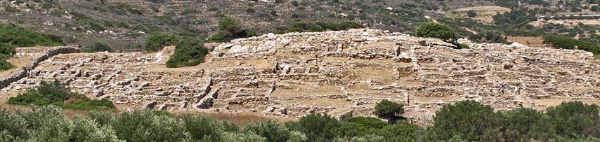
Buildings in the east part of the town
The Late Minoan town of Gournia was excavated by Harriet Boyd in the first years of the 20th century. It is one of the few Minoan towns to have been fully excavated. The original name of the settlement is not known and its present name comes from the hollow vessels found all over the site, many of which can still be seen at the entrances to the rooms.
Gournia lies on a small hill, a few hundred metres from the sea in the Gulf of Mirabello. Its position is important as it lies on the east to west route along the north coast of Crete but also near the main route in this area between the north and south coasts of Crete. This is the point where Crete is at its most narrow and the route from modern day Ierapetra in the south to the village of Pachyamos on the north coast, a few kilometres from Gournia, does not even cross mountains, making the route a very easy one to travel.

A house in Gournia
It is thought that the town may have extended down, almost to the seashore, in an area bounded by a steep hill to the east (Sphoungaras) which was used as a cemetery and a river to the west. The remains of the shoreline installations can be seen on a separate page on this website, (link at the bottom of this page).
Early habitation
From pottery finds in the Sphoungaras area it is known that groups of neolithic people were settled in the area around Gournia in the period up to 3000 BCE, that is to say, the Late Neolithic period. The next evidence we have for settlement in the area dates to 2500 BCE in the Early Minoan period. It is almost certain, however, that the area was continuously inhabited during the intervening 500 years; it is just that no finds have been made yet to establish this.
There is evidence of continued occupation through EM II and EM III, with both pottery finds and burials. At Sphoungaras, where there are rock overhangs, the settlers built walls to create small covered areas where the dead were buried.
The first palace period

Gournia took its modern name from the large number of these objects found on the site
Much of what existed on the site of Gournia during this period was levelled and built over during later building phases. It is thought, however, that the basic lay-out of the town was established at this time, although no palace appears to have been constructed at this stage. It has been argued that the size of the population reached 400 people. A few buildings survived the levelling of the area which took place at the end of the first palace period around 1700. Among these was House Aa, a large two-storied house in the north east part of the town.
New forms of burial are introduced in this period. In the first type the dead are buried in inverted pythoi which are placed in pits in the ground. (Pythoi are enormous clay vessels, more commonly used for storing and transporting foodstuffs). The other new type of burial is in house tombs. These consisted of one or two small rooms in which the dead and their grave goods were placed. Similar house tombs have been found at Mochlos, some kilometres further east along the north coast.
The new palace period
Around 1700 BCE parts of the top of the town were levelled off and a new stage of building began, giving us the town as we see it today. A palace is built for the first time, and this represents a major change in the way society in the Gournia area is organised. As happened previously in other parts of Crete when a palace was built, the surrounding villages were abandoned as the population was presumably incorporated into the new town.
The palace itself is squeezed into the southern part of the town. The most dense concentrations of buildings lie to the north and east of the palace as the gorge which the river flows through approaches quite close to the west side of the hill.
The Late Minoan palace

The Palace
The palace building measured 50 metres by 37 metres and faced south across the courtyard, which was approximately 40 metres by 15 metres. Consequently it was much smaller than the main palaces like Knossos, Phaistos and Malia. Moreover, the courtyard had to be placed outside the palace whereas normally it would be surrounded by the four wings of the palace. There is no real West Court at Gournia like there is at the palaces. The road leading past the West Facade was simply widened at this point.
Visiting the site today, it is very difficult to make out the actual dimensions of what remains of the palace. Because it was built on a hill, levelling the ground before building seems to have been ruled out and the palace was built on three terraces. The bottom terrace, the West facade, was made up of storerooms on the west side of the structure, running on a north-south axis. This follows the traditional design for the palaces. The second level originally started above these storerooms and continued east onto the solid rock of the hill.
That part of the second level which was built above the western storerooms no longer exists so what we see today is the remains of the storerooms to the West which seem to merge into what was originally the second level of the palace where this was built on the hill itself and so its ruins have survived. The top floor would have collapsed during the destruction of the palace.

The small theatral area
The palace also contained a lustral basin and light well. There were three entrances to the palace, from the south, west and northeast. Because the palace was so small, the "central court" was placed outside to the south. Built into the structure of the palace at the north end of the "central court" are two sets of four steps, placed at right angles to each other. These steps resemble the theatral areas of the main palaces. They also formed the south entrance to the palace. Unlike the other theatral areas, however, this one faces the central court, rather than the west court. It is also on a considerably more modest scale than other theatral areas.
At the top of the set of steps that run north-south, there is what might be a sacrificial stone. It has been suggested that holes carved in the stone may have enabled a table to be slotted in, on which the animal to be sacrificed was tied. Objections have been raised however that the location of the holes would not allow for a table large enough to hold an animal for sacrifice and that the stone slab itself may have served as the sacrificial spot. Another hole in the stone slab may have been used for fixing a religious symbol, for example a double axe.
The palace, together with the surrounding town, was destroyed by fire around 1450 BCE, at a time when every major Minoan settlement on the island was also either destroyed by fire or abandoned.
To the north of the palace, and separate from it, a small civic shrine was found, dating to the LM I period. This small shrine was 3 metres by 4 metres and approached up three steps. It had a ledge on the south side for the placing of cult objects. In the shrine, the finds themselves dated from a much later period and included idols of a goddess with raised arms and a clay vessel with handles on either side in the form of snakes and a relief of horns of consecration.
The Late Minoan town

Steps lead up through the industrial town to the Palace area at the top of the hill.
The town which grew up in Late Minoan IA covered an area of 25,000 square metres. It can be divided into seven separate quarters. Two roads encircled the lower and upper parts of the town, joined together by steps at various points. The estimated population of the town was 4,000.
The numerous houses are small and tightly packed together. Many of the surviving rooms were most likely basements used for storage and entry to the houses would, in many cases, have been by steps leading up from the street. Some of these steps can still be seen.
Other houses were entered directly at street level and large threshold stones can still be seen at the entrance to many of these houses. Access to the basements would have been down wooden stairs or ladders, through a trapdoor from inside the houses.
Among the finds on the site are potters' wheels, a carpenter's workshop complete with saws and other tools, a coppersmith's forge and an oil press.
Minoan houses

Flat stone probably used for blood sacrifice. A table may have been inserted in the holes, and an animal sacrificed on the table.
An idea of what Minoan houses looked like can be gained from the ivory and faience plaques discovered in the East wing of Knossos. These plaques show what houses in the town of Knossos looked like in the 17th century BCE.
On the roof there was a small room. This may have been used for sleeping in during the hot summer months. The rooms on the first floor had windows, but those on the ground floor did not, although some of them had doors on the ground floor. It may be that windows on the ground floor were avoided for simple reasons of security -- to avoid burglary.
The houses were built around a wooden frame -- wooden beams ran horizontally and were linked to upright beams. The most likely reason for the use of these beams was as protection against earthquake damage.
The post palatial period
The area around Gournia suffered depopulation in the ensuing period, represented by the rule of the Mycenaeans in the centre and west of the island. It is not known if Gournia itself was completely abandoned, but this seems unlikely as attested by the fact that one house was clearly occupied throughout this period and the cult objects in the shrine date from LM III. Burials from this period have also been unearthed in the area. It is thought that the site was finally abandoned around 1200 BCE
The site is open to the public from 8.30-3.00 (entrance 2 euros in 2012). Very few tourists visit the site which means you can enjoy the remains of this Minoan town at your leisure. A good view of the whole of the east part of the the town can be had from the main Agios Nikolaos-Siteia road. To reach the harbour installations (link to page on the right) walk down the dirt track from the entrance to Gournia archaeological site until you reach the main road. Cross the main road and turn left. Walk a hundred metres or so until just before the bridge over the ravine. Turn right down the track here and walk down to the shoreline.