
Mochlos
Location and excavations

The coastal plain, looking West, with the island of Mochlos
The island of Mochlos is situated just east of the Gulf of Mirabello in Eastern Crete. The island, together with the coastal plain to which it was almost certainly physically joined by a narrow spit in Minoan times, effectively forms a distinct geographical area somewhat cut off from the rest of Crete by the Ornos mountains to the south.
The island was first excavated in 1908 by the American Richard Seager, who found a prepalatial cemetery on the western end of the island. He uncovered 20 built tombs, pithos burials and pit graves. On the Western tip of the island, he discovered two large tombs which he considered were used for the burial of members of the ruling elite. This view was based on the size of the tombs, the wealth of the grave goods and the fact that they had been constructed some distance from the other tombs. Most of the tombs were built in the EM II period and used at least until EM III while a few seem to have been used during MM IA. Then they were abandoned, but brought back into use during the Neopalatial period. It wasn't until the 1970s, however, that Professor Jeffrey Soles drew detailed plans of the cemetery and identified all the tombs. (The cemetery is described in more detail on the third page dedicated to Mochlos. Follow the link at the top of this page).
Meanwhile other archaelogists also excavated on the island and in the coastal plain opposite in the decades which followed with the result that about twenty-five sites, representing the whole Bronze Age from EM I to LM IIIC as well as later periods, have been reported. In 1989 Soles and Davaras began the most thorough cleaning and excavating of the cemetery and the neopalatial settlement on Mochlos ever to take place. This work continues today.
The Early Minoan town

The royal tombs from the prepalatial cemetery
The main settlement is to be found on the south side of the island. There is evidence that the area was first settled in the Final Neolithic-Early Minoan I period. A sealed deposit of EM I material below tomb V in the prepalatial cemetery points to the possibility that the cemetery area was already used for burials in EM 1.
There is far more EM II than EM I pottery at Mochlos and of the EM II pottery, not much from EM IIA. Branigan believes that the large-scale growth in occupation of the site came in the latter part of EM II because almost none of the stone vases and bronzework from the tombs are likely to date earlier than EM IIB. Moreover, Branigan argues that the continued use of the EM II houses through the EM III period at Mochlos, which Seager had noted in his original 1909 excavation, is more easily explained if they weren't actually built until EM IIB.
This EM II growth of the settlement was probably due to an influx of settlers from central Crete. Among the attractions for settlers would have been the harbours situated on either side of the isthmus joining Mochlos to the mainland and the large coastal plain which would have been suitable for agriculture. Todd Whitelaw estimates that the settlement may have grown to 0.8 hectares, giving it a population of between 220 and 330 people. It is not known if or how far the settlement extended on the other side of the spit into the coastal plain, but the total settlement could have had up to 500 residents.

The East Pillar Crypt with the West Pillar Crypt in the background.
Whitelaw argued that a community of this size would almost certainly have seen the emergence of a social hierarchy over time. Soles, however, following on from Seager, argued that the best evidence for social ranking in Early Minoan Mochlos came from the tombs. Tombs I-III and in particular tombs IV-VI are by far the most impressive tombs in the cemetery with architecture in a different league from the other tombs. Moreover, the grave goods, clearly made of rare materials by skilled craftsmen, would only have been available to a small minority of the population. Tombs I-III and IV-VI contained collections of gold and silver jewellery and stone vases the like of which was not found in any other tomb. Another high status find, from tomb II, was a decorated dagger which Branigan considers the finest ever found from EM Crete
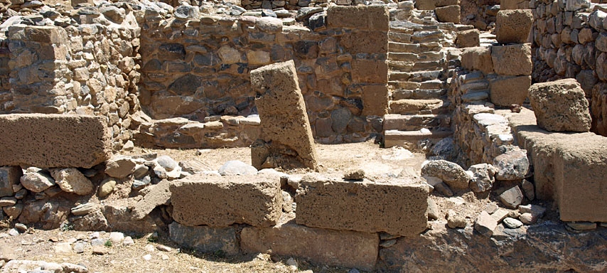
 Close-up of the steps leading from the East Pillar Crypt up to the second floor of House B2
It seems certain that Mochlos had become the focus for new industries including the manufacture of gold jewellery, stone vases, and faience. As Branigan points out, the collection of stone vases found in the cemetery is the fourth largest in Crete and the distinctive appearance of the vases means that they were almost certainly produced locally. The gold found in the cemetery was also distinct from the gold found in the tholos tombs of the Mesara. Indeed some stone vases and goldwork found at other Minoan sites are thought to have come from the workshops of Mochlos.
The presence of workshops in Mochlos using raw materials, like gold, that are not available locally, implies trading relations beyond the island of Crete. Gold may have come from Euboea or Macedonia, while some of the silver worked at Mochlos has been identified as originating in the Cycladic island of Sifnos. There is also evidence that some artifacts found at Mochlos came from the Near East. Branigan compared the amount of gold found at Mochlos with quantities found elsewhere in Crete from the Early Minoan period and the result is quite surprising. Over 40% of all the individual gold items and 50% of the value of all the gold found in EM Crete deposits come from Mochlos alone.
The north coast of Crete, from Knossos in the centre to Palaikastro in the far east, has been considered by some as an area that was greatly influenced by the peoples of the Cycladic islands in the Early Minoan period. But according to Branigan, the temptation to explain the enormous quantity of imported raw materials and wealth centred on Mochlos as resulting from the settlement of Cycladic people in the area must be avoided for it appears that Mochlos is the least dominated by Cycladic influences of all the Early Minoan sites in this part of Crete. Everything produced at Mochlos was distinctly Cretan in character. According to Branigan, "the evidence of EM Mochlos...suggests to me that it fits well the type of settlement described by Carol Smith (1976) as a monopolistic market, controlling exchange within and into and out of a region, including that to and between elite sites." Branigan used a term coined by Hirth in 1978 to describe this type of settlement as a gateway community. (See Branigan's paper, cited below, for more details. Get a pdf copy here).
A town of reduced importance
 An alleyway leading north between two Blocks
During MM IA the number of burials in the Prepalatial cemetery fell off dramatically. It seems that the population at Mochlos may have gone into decline and its activities became more limited. Seager claimed to have found evidence of a MM IA destruction but did not produce any further evidence to back up his assertion.
At this time, another group of settlers arrived in the area. These settlers had different burial customs, building a tholos tomb at Galana Charakia, about three kilometers to the east. These people may have come from the Mesara Plain in southern Crete, where tholos tomb burials were the norm. Just why these people would have left the largest fertile area in Crete and moved to the north coast is not known.
In the New Palace period, a small town flourished on the south side of Mochlos and some of the tombs in the old cemetery were put back into use. However, the Neopalatial town never attained the importance of the Prepalatial settlement. Its chief contacts were probably with the town of Gournia in the Bay of Mirabello. A quarry on the plain opposite the island provided the stone used to form the ashlar masonry used in the construction of the "palace" at Gournia.
The town was destroyed by fire at the end of LM IB and although the cause isn't known, Seager claimed that the presence of human bones in the destruction levels pointed to a violent attack rather than an earthquake as being responsible for its destruction.
The area was resettled during the Mycenaean period. LM III chamber tombs have been excavated on the Cretan mainland opposite the island. The large number of chamber tombs discovered two to three kilometers to the east of the island poses the possibility of a Mycenaean settlement in that area, up in the hills behind the coastal plain. Evidence from the tombs points to a reoccupation in LM IIIA and possibly earlier. The area continued to be occupied into LM IIIC after many sites in Crete had been abandoned. Since the finds from LM III are of such high quality, it has been suggested that the settlement along this part of the coast had its own pottery workshop and maintained contacts with mainland Greece.
The Neopalatial town

Part of the LM I town
The main remains to be seen on the island today date from the LM I town, which extended across the isthmus to an area behind the modern village of Mochlos. Four Blocks of houses have been excavated on the island and named Blocks A, B, C and D. Between each Block a narrow street runs north from the shoreline and other narrow streets run in an east-west orientation.
The ceremonial centre lay to the north-west of the town. It was a three-storey building, with ashlar walls, named House B2 by excavators. Two pillar crypts were found on the ground floor at the east end of the building. The remains of a staircase leading from the pillar crypt to the upper floors can still be seen. The building also contained a kitchen and possibly a dining room. It was the largest building in the LM I town. It is described in detail on the next page.

Part of the LM I town
Behind the modern town of Mochlos, excavations have uncovered two buildings of artisans' quarters dating back to LM IB. One building was used for bronze, ivory and stone vase making, while the other was used for pottery. Both buildings seem to have been inhabited and contained a shrine. Another LM IB building has been excavated at Chalinmouri at the eastern end of the coastal plain. Finally, an LM III cemetery has been excavated. It contained 30 chamber tombs and was located on a hill opposite the site of the LM III settlement. The unlooted tombs each contained one or two burials, either in sarcophagi or pithoi. These are described in more detail on the last page dedicated to Mochlos.
Access
A turning from the main Agios Nikolaos-Siteia road leads down to the harbour where local fishermen will take you across the couple of hundred metres of sea to the island. Helpful signs have been put up around the archaeological site offering some explanation of what you are looking at. To view the prepalatial cemetery walk west from the archaeological site and you will pick up the path which takes you up to the cemetery.
Much of the information contained on this page has been sourced from the reports of the excavations published in Hesperia and the article Mochlos -- an Early Minoan 'Gateway Community'? by Keith Branigan. Another source was the excellent Mochlos web site, which has been created to detail the ongoing excavations led by Professor Jeffrey Soles and Costis Davaras. There is a link to the Mochlos web site on the resources page.